Crossing the Landscape
One of the things I love about bicycle touring is how it structures your relationship to geography. You notice every slight up and downhill. You care about slight variations in road surface.
But, it's thinking about how to cross stuff that has had the biggest impact on me.
For longer trips we generally follow vies verdes / rails to trails type routes and getting from A to B is straight forward. We don't always have time for those kind of trips though. So sometimes on the weekend we do an overnight camping trip, often in combination with a short train ride. For these we usually have to make our own route, for at least part of the journey.
With a car (or a cycle path in the Netherlands!) you get on the road, follow the signs, and don't worry about anything stopping you. Bridges and underpasses help you across rivers, freeways, and train tracks no problem.
Unfortunately on a bike—especially if you are trying to avoid sharing a busy road with cars—that isn't always the case. Plotting routes out of the city has made me acutely aware of the way landscape, rivers, freeways, and train tracks all interact with each other and the ways that they both connect and, often, divide, nearby communities. And even when you can cross by bicycle, where a car is usually allowed to take a straight flat connection you are often forced into detours and elevation changes that more closely hug the original geography of the land.
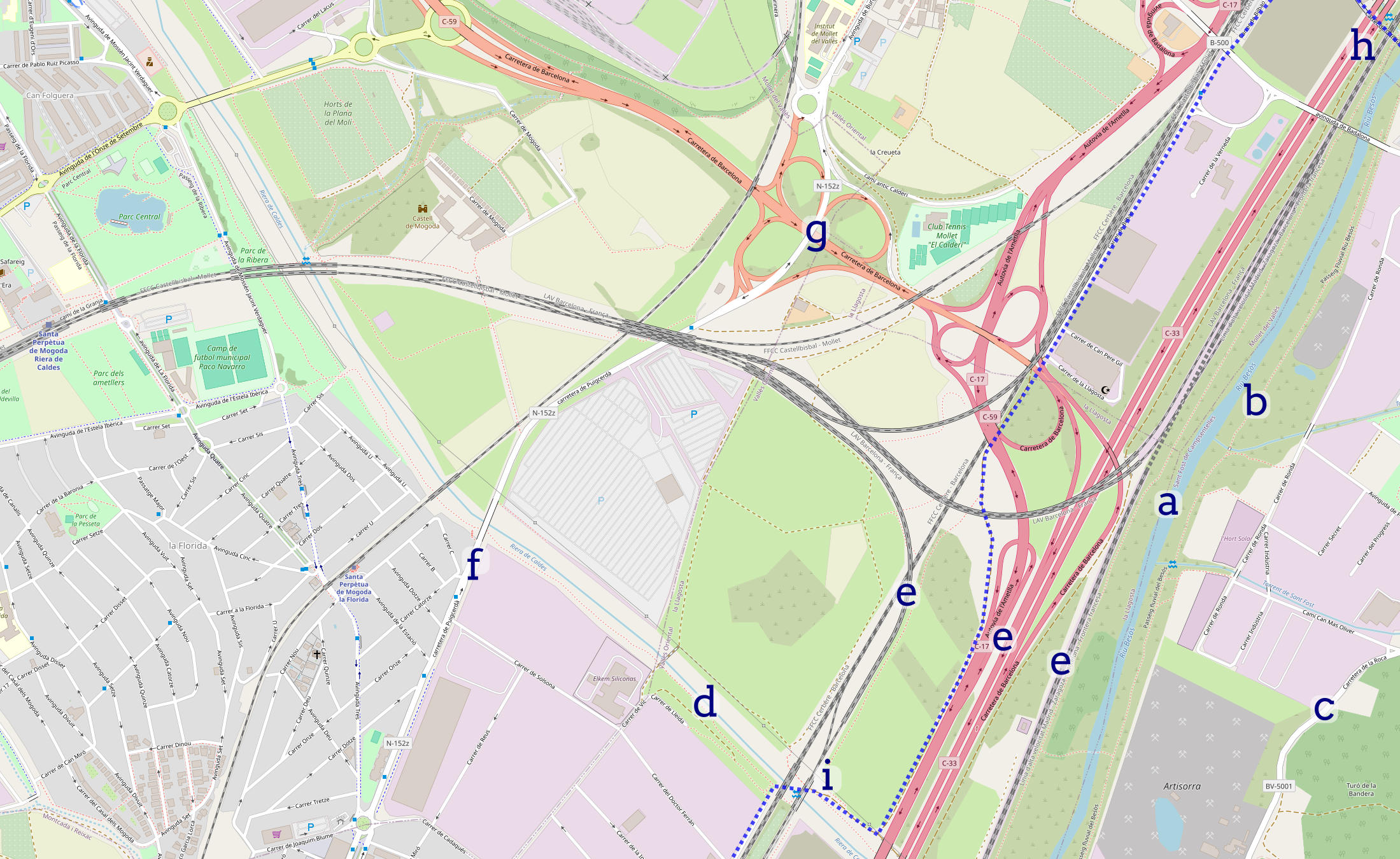
For example, going from La Llagosta to Mollet del Vallès. On the left bank of the Besòs river [a] there is either a path that is unsuitable for biking [b] or the BV-5001 [c], which is too busy for my taste (yes, I know lycra-bros do it all the time). On the right bank we have to figure out how to cross the Riera de Caldes [d], which shouldn't be too bad because it's pretty small and usually dry. Obviously we can't take the C-33, C-17, or any of the train tracks [e]. Carretera de Puigcerdà [f] looks promising. Except, it's actually the N-152z here (i.e. a freeway access road). It crosses the C-59 via an unpleasant looking overpass [g] with cars de/accelerating from/to freeway speeds. Doable but very far from ideal.

Except even a little bravery doesn't actually help! Going that way you'd be stuck on the wrong side of the C-17, and train tracks, because the only bikeable bridge [h] back across the Besòs isn't accessible from Mollet del Vallès except via either the freeway or a bunch of stairs. So if you want to keep going up the Besòs you would have to first take a detour into Parets de Valles and through Montmeló. Luckily there is an alternative. There is a weird little ford across the Caldes [i], with a path to it and everything, right by the train tracks. It works! I've taken the dotted path. (A whole other topic is my amazement at just how many random dirt access paths there are everywhere.) But, it's amazing how one mostly dry river bed and a whole bunch of infrastructure meant to connect stuff, divides these two towns.
Posted on 17 October 2024 by Jedidjah de Vries — 3 min